Iditarod Trail Info | Map
Iditarod Trail Map | Iditarod Checkpoint Info | Iditarod Fly-out
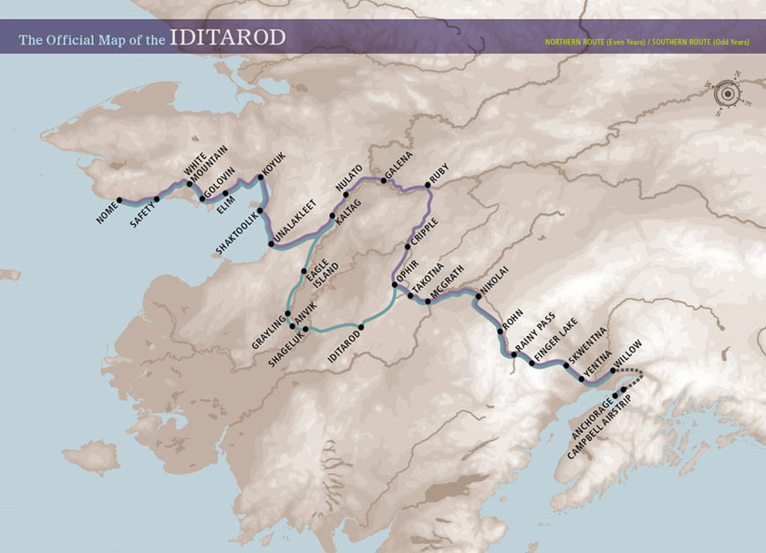
The
Iditarod Trail Sled Dog Race is run in the middle section on an annual
alternating northern and southern route around the Innoko National
Wildlife Refuge. In even-numbered years, participants must complete the
northern route; in odd-numbered years, since 1977, they must complete
the southern route. Other than alternating routes, the course layout has
changed only slightly since it was first held in 1973. Major changes
have been the introduction of the restart and the change from Ptarmigan
to Rainy Pass.
As a result of these changes, the effective length of the route also
varies. Officially, the actual length of the northern route includes
1112 miles (1790 km) and the southern 1131 miles (1820 km). However,
often the length is given as 1049 miles in allusion to the fact that
Alaska is the 49th state of the United States. However, this is of only
secondary importance to the actual course of the race, as the mushers
are free to travel between the individual checkpoints.
Checkpoints
Along the route to Nome there are 26 (northern route) and 27 (southern
route) checkpoints, where the mushers have to report with their teams
and where they can fill up their provisions, have a rest or change
sleds. Otherwise, the route choice is free. Once each participant must
take a break of 24 hours, twice one of eight hours. This is to prevent
the dogs from being overworked. The health of the animals is also
constantly checked by veterinarians.
Our Iditarod Tour Packages "Iditarod
Chase the Race" and "Iditarod
and Northern Lights Tour" take Iditarod fans to
Rainy Pass and Nikolai Checkpoints.
Iditarod Trail - Iditarod Sled Dog Race Wilderness Checkpoints
|
|
|